There's a version of America that's only accessible by road — small towns between interstates, landscapes that change hour by hour, diners where the coffee is bad and the conversation is genuinely good. The America I've seen from planes and in major cities is extraordinary. The America I've seen on road trips is something else entirely, and I wouldn't have missed it for anything.
Choosing Your USA Road Trip Route
The United States is too large for a single definitive road trip route. The approach that works: choose a specific region and cover it thoroughly rather than attempting coast-to-coast in under 3 weeks. The best regional circuits in 2026:
Route 1: The American Southwest — 10–14 Days
American road trips require different planning than European ones — the distances are genuinely vast, and the infrastructure, while excellent on major routes, drops off quickly in rural areas. This guide covers the planning realities alongside the inspiration.
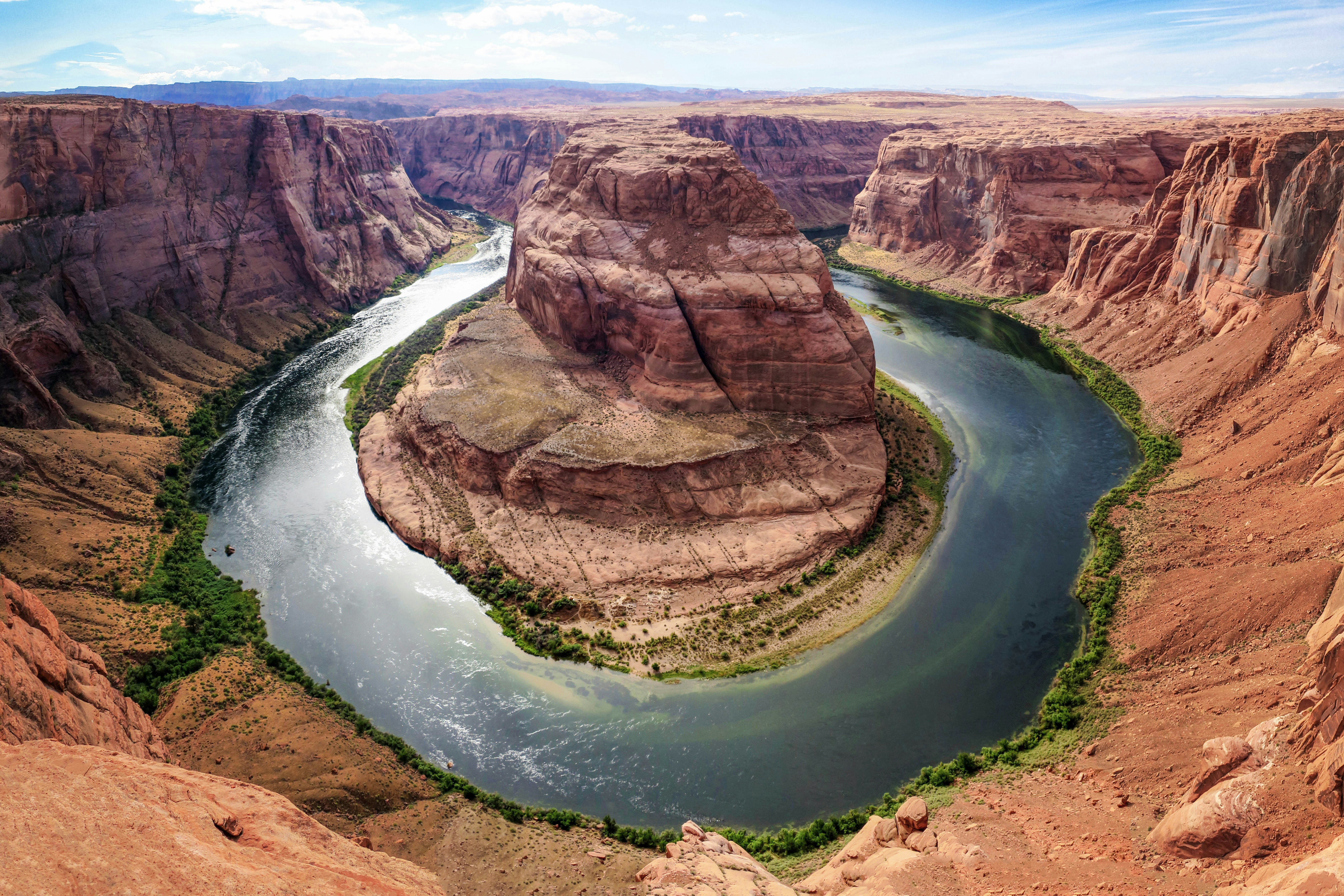
The Southwest circuit is the USA road trip that delivers the most concentrated natural spectacle per mile — a landscape of red rock formations, ancient civilizations, and national parks that justify the country's entire National Park system. Starting from Las Vegas:
- Zion National Park (Utah): The Virgin River Narrows — a slot canyon hike through thigh-deep water between 300m walls — is one of America's finest outdoor experiences. The Angels Landing trail (permit required via lottery at recreation.gov) provides the most dramatic overview. Book accommodation in Springdale (the gateway town) 3–6 months ahead; summer fills completely.
- Bryce Canyon National Park (Utah): 60 million years of erosion created the hoodoos — orange limestone columns in their thousands, standing in natural amphitheatres of extraordinary visual density. The Rim Trail (5.5 miles) provides the most comprehensive overview; the Queens/Navajo Loop (3 miles) descends into the hoodoo forest for the most immersive experience.
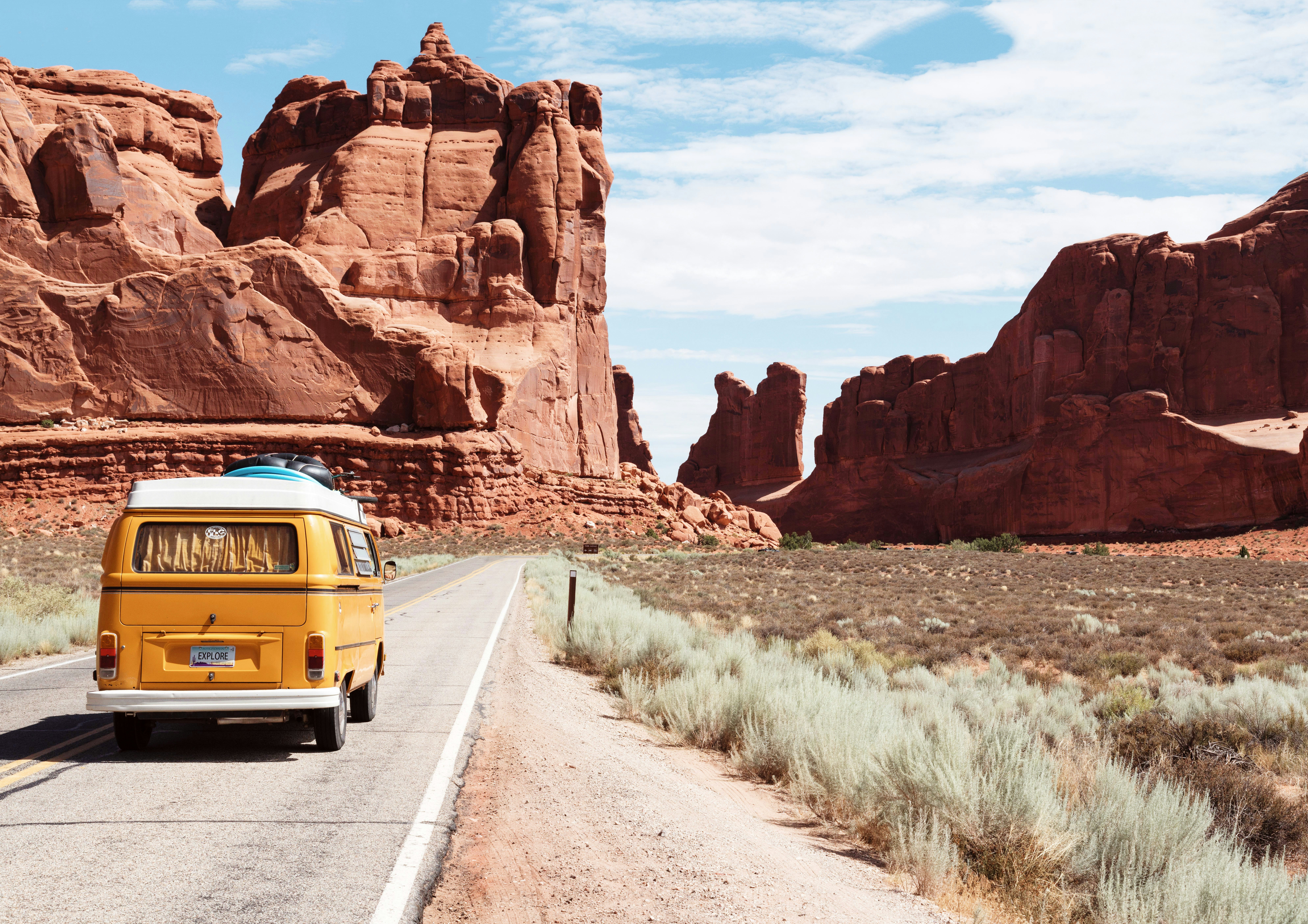
- Arches National Park (Utah): 2,000+ natural stone arches including Delicate Arch — the lone arch standing on a slickrock bowl above the Colorado River canyon that has become Utah's defining image. The 3-mile round-trip hike gains 480 feet; the last quarter-mile uses foot-worn grooves in the slickrock. Sunrise and sunset provide dramatic colour; timed entry permits are required (free, recreation.gov).
- Monument Valley Navajo Tribal Park (Arizona/Utah): The sandstone mittens and buttes that have defined America's visual identity in a century of Western films — John Ford shot 9 films here, including Stagecoach and The Searchers. The 17-mile Valley Drive dirt road (self-driven or guided) visits the main formations. The only accommodation within the park (The View Hotel) provides sunrise and sunset views of the Mittens from its restaurant and rooms — book 6+ months ahead.
- Grand Canyon South Rim (Arizona): The canyon's scale — 1.6km deep, 16km wide, 450km long — genuinely cannot be conveyed by photographs. The Bright Angel Trail descends into the canyon (4km to the 3-mile resthouse with water; 9.5km to the Colorado River — a 2-day backcountry trip requiring permits). The South Rim is open year-round; the North Rim closes November–May. Entry $35 per vehicle, valid 7 days.
Practical planning: book all national park accommodation and permits as far ahead as possible — popular parks now require timed entry reservations (Arches, Zion, Rocky Mountain) during peak season (late May–early September). Buy the America the Beautiful Pass ($80, valid 1 year) for access to all 400+ national parks and federal lands — it pays for itself after 2–3 parks. Use our car rental guide for USA-specific advice including minimum age requirements and one-way rental strategies.
✈️ Start Your USA Road Trip
Find cheap flights to Las Vegas, Denver, or Seattle and book your road trip accommodation.
✈ Search Flights 🏨 Book Hotels 🎫 Book ToursRoute 2: Pacific Coast Highway — 10–14 Days
California State Route 1 between San Francisco and Los Angeles (or extended to San Diego) is the world's most famous coastal drive — 600+ miles of cliffside road above the Pacific, passing through Big Sur's redwood-covered mountains, Hearst Castle, Pismo Beach, and Santa Barbara's Spanish Colonial architecture before arriving at Los Angeles.
- San Francisco: Start with 2–3 days in the city — the Golden Gate Bridge at dawn in fog, the Ferry Building Marketplace, Mission District's murals and burritos, and a cable car ride for transport rather than tourism. The most consistently beautiful American city.
- Highway 1 through Big Sur: The most dramatic section — 90 miles of cliffside driving past Bixby Creek Bridge, McWay Falls (80-foot waterfall onto a beach accessible only by boat), and the Henry Miller Memorial Library. Drive slowly. Stop constantly. The Pacific is 300 metres below on one side; the Santa Lucia Mountains rise on the other.
- Hearst Castle: The newspaper magnate William Randolph Hearst's hilltop estate of 165 rooms and 127 acres, built between 1919 and 1947 by architect Julia Morgan. The excess is its own kind of extraordinary — the Neptune Pool, the assembly room with 15th-century Spanish choir stalls, and the collection of ancient Greek and Roman art create a monument to American Gilded Age ambition. Guided tours from $35.
- Los Angeles: End with 3 days — the Getty Center's architecture and collection (free entry), the Getty Villa's Greek and Roman antiquities, Joshua Tree National Park for a day trip (3 hours east), and the Venice Beach boardwalk for the most compressed Los Angeles atmosphere.
Route 3: New England Fall Foliage — 7–10 Days (September–October)
The autumn foliage of New England (Massachusetts, Vermont, New Hampshire, Maine) is one of the world's great seasonal travel events — 6–8 weeks of maple, birch, and oak trees cycling through yellow, orange, and crimson in a progression that moves south through the region from mid-September to late October. Peak timing varies by year and elevation — the Foliage Network website provides real-time peak predictions by county.
The circuit: Boston (2 days) → Concord and Lexington (day trip, American Revolution history) → White Mountains, NH (Mount Washington cog railway, Kancamagus Highway) → Stowe, VT (ski town at peak foliage, Ben & Jerry's factory tour) → Burlington, VT (Lake Champlain) → Portland, ME (lobster rolls at the waterfront, extraordinary food scene) → back to Boston. Total distance: approximately 800 miles. Book accommodation in Vermont and New Hampshire 3–4 months ahead for peak foliage weekends.
Road Trip Practical Guide
- Car rental timing: Book 4–6 weeks ahead for standard SUVs; 8–12 weeks ahead for peak summer season in popular destinations. One-way rentals between different cities are available but charge a drop fee ($100–$300) — factor this into your comparison. See our car rental comparison for the best US rates.
- Gas: US fuel prices vary significantly by state (California is typically 30–40% more expensive than Texas or Nevada). Fill up outside city limits and in rural areas where competition keeps prices lower. GasBuddy app shows real-time prices along your route.
- Accommodation: Chain hotels (Hampton Inn, Courtyard by Marriott) provide consistent quality at $100–$180/night. Independent motels on Route 66 and highway corridors provide nostalgia at $60–$100/night. Campgrounds in national park areas ($20–$35/night, book via recreation.gov) are the most atmospheric and budget-friendly option. Apply our last-minute hotel booking strategies for same-day savings on spontaneous night stops.
- Speed limits and law: US speed limits are strictly enforced — state highway patrol uses unmarked vehicles extensively. Speed limits drop to 25mph through small towns regardless of highway speeds before and after. Keep documentation (license, rental agreement, insurance) accessible during drives.
Route 4: Alaska Highway and the Last Frontier
Alaska represents America's most dramatically remote road trip — and the Alaska Highway (the ALCAN, built in 1942 connecting the contiguous US through Canada to Fairbanks, Alaska) is the world's most legendary frontier drive. Most Alaskan road trippers fly into Anchorage and explore by rental campervan:
- Kenai Peninsula (3–4 days from Anchorage): Homer's dramatic Spit (a 7km natural gravel bar extending into Kachemak Bay), the Kenai Fjords National Park boat tours (glaciers calving into the sea, puffin colonies, orcas), and the Kenai River's salmon runs draw brown bears from the surrounding wilderness in August–September
- Denali National Park (4–5 hours from Anchorage): The national park has only one road (92 miles), accessible beyond the first 15 miles only by park bus (booked months ahead) — this controlled access maintains wildlife density at extraordinary levels. Grizzly bears, wolves, caribou, moose, and Dall sheep alongside North America's highest peak (6,190m) when clouds permit the view (roughly 30% of visits)
- Fairbanks (Interior Alaska): The northern lights from Fairbanks (September–March when nights are dark) are exceptionally accessible — the Aurora Borealis forecast apps routinely show KP5+ conditions at Fairbanks's latitude throughout winter. The Chena Hot Springs (100km from Fairbanks) provide the quintessential Alaska experience: soaking in outdoor geothermal pools while northern lights dance overhead at -20°C
Alaska road trip budget: $250–$400/day for two people including rental campervan ($150–$200/day), fuel (Alaska has the lowest gas prices of any US state despite remoteness), campground fees ($15–$35), and food. Book rental campervans through Cruise America, Outdoorsy, or RVshare 6+ months ahead for summer peak season (June–August). Use our travel insurance guide for Alaska-specific adventure activity coverage — wildlife encounters and remote hiking require explicit coverage that basic policies exclude.
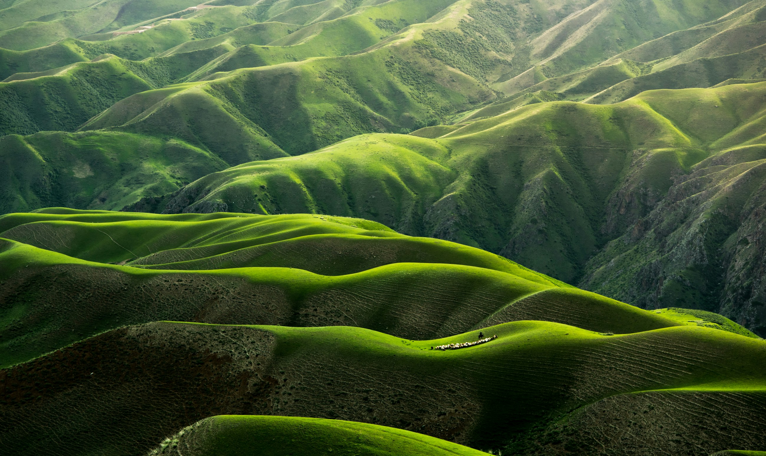
The Most Underrated USA Road Trip: The Blue Ridge Parkway
The Blue Ridge Parkway — 755km through Virginia and North Carolina along the crest of the Appalachian Mountains — is the most driven national park unit in the US and among the least internationally known. No commercial traffic is permitted on the Parkway; the speed limit is 45mph; and the road's access to Appalachian culture (craft studios, folk music, moonshine distilleries), fall foliage (mid-October is peak), and hikes to extraordinary viewpoints creates a road trip of quiet excellence that completely lacks the Instagram positioning of the Southwest's red rocks.
Key stops: Roanoke, VA (excellent food and music scene); Mabry Mill (the most photographed grist mill in America, operating on weekends in summer); Asheville, NC (the most creative small city in the American South — extraordinary food, craft beer, and arts scene); and Great Smoky Mountains National Park at the southern terminus (the most-visited national park in the US, free entry, extraordinary biodiversity). September–October sees 10–15 million Parkway visitors — book accommodation in Asheville 2–4 months ahead for foliage peak.
Road Trip Apps and Technology Guide 2026
The technology stack that experienced USA road trippers use in 2026:
- Roadtrippers Plus ($30/year): Purpose-built road trip planning tool — maps your route with waypoints, estimated driving times, fuel costs, and points of interest within defined distances of your route. The most useful planning tool for multi-day road trips with flexibility built in.
- GasBuddy (free): Real-time fuel prices from stations along your route — typically saves $15–$30 per tank in high-price states (California, Hawaii, New York) by routing to the cheapest nearby station.
- iOverlander (free): Community-reported free camping locations — essential for dispersed camping on Bureau of Land Management land in the Southwest, where you can legally camp for free within defined distances of roads.
- recreation.gov: Official US national park permit booking — timed entry reservations for Arches, Zion, Rocky Mountain, Glacier, and more are required during peak season. Book immediately when the reservation window opens (typically 90 days before the date at 8am Mountain Time).
- Waze: Real-time traffic and police reporting, superior to Google Maps for avoiding slowdowns on Interstate highways and major urban freeways. Essential for LA freeways and I-95 corridor driving.
For international visitors: US SIM cards from T-Mobile, Verizon, or AT&T provide the best rural coverage at affordable prices ($30–$50/month for unlimited data). T-Mobile provides the best coverage in rural Western states. Verizon leads in the Southeast and Midwest. Both T-Mobile and AT&T sell tourist-specific 30-day plans at major airports. See our travel apps guide for the complete road trip technology setup.
Frequently Asked Questions About USA Road Trips
How much does a USA road trip cost per day?
$150–$250 per person per day is realistic for a 2-person trip — car rental ($50–$80/day), accommodation ($70–$150/night), fuel ($15–$25/day), and food ($30–$50/day). The $80 America the Beautiful Pass pays for itself after 2–3 national park visits. Use our vacation savings guide to reduce costs.
When is the best time to road trip the USA?
Southwest parks: March–May and September–October avoid summer heat and crowds. Pacific Coast Highway: May–September for reliable weather. New England foliage: mid-September to late October. Alaska: June–August for the best conditions and longest daylight.
Can I drive in the USA with a foreign licence?
Yes — most nationalities can drive in the USA for up to 1 year with their home country licence. An International Driving Permit (IDP, available from your national automobile association) is a recommended supplement. Rental companies may have additional age requirements (typically 21 minimum, 25 for no young-driver surcharge).